Weekend forecast (10/9-10/12): Second summer heat breaks Sat. with gusty winds, cooler temps, and showers Sun. - Mon. High elevation snows possible

Updated: Oct 11
An abrupt pattern change arrives this weekend closing out anomalous October warmth with strong winds, sharply cooler temperatures and late weekend chances for wetting rains and modest high elevation snows.
Fri, 10/9/2026: 6:00am - Sat, 10/10/26: 6:00am | |||||||
Temps (Max/Min) | Wind | Cloud Cover | Precip Prob | Precip Amt | Precip Type | Notes | |
7000-8500' | Max: 66-70° Min: 47-52° | SW @ 15-20mph Gusts to 30mph | Few/Scattered | 0% | n/a | n/a | SW winds increasing Fri. Fire wx concerns with low RH Fri PM |
8500-10k' | Max: 57-64° Min: 43-47° | SW @ 25-35mph Gusts to 50mph+ | Few/Scattered | 0% | n/a | n/a | SW winds increasing Fri. becoming gusty |
Sat, 10/10/2026: 6:00am - Sun, 10/11/26: 6:00am | |||||||
Temps (Max/Min) | Wind | Cloud Cover | Precip Prob | PrecipAmt | Precip Type | Notes | |
7000-8500' | Max: 53-58° Min: 34-39° | SW @ 20-25mph Gusts to 35mph | Scattered becoming overcast PM | <5% | n/a | rain | Winds peak late Sat, fall off overnight becoming S-SE |
8500-10k' | Max: 45-53° Min: 30-34° | SW @ 45-55mph Gusts 60+ mph | Scattered becoming overcast PM | 10% | trace - .05" | mix | Winds peak late Sat, light mixed precip possible Sun AM |
Sun, 10/11/2026: 6:00am - Mon, 10/12/26: 6:00am | |||||||
Temps (Max/Min) | Wind | Cloud Cover | Precip Prob | Precip Amt | Precip Type | Notes | |
7000-8500' | Max: 45-50° Min: 28-35° | SSW @ 10-15mph | Scattered to broken overcast | 30% | trace to .05" liq | mix rain to snow | Chance rain/snow showers late PM and snow levels drop into Mon AM ~7500' |
8500-10k' | Max: 37-45° Min: 26-30° | SSW @ 15-25mph | Scattered to broken overcast | 30-40% | trace to 1" frz / .01-.08" liq | snow | Chance PM snow showers through Mon AM |
Backcountry Obs:
There's not much change from last week's report of peak dust and muted fall colors throughout the backcountry. A few light showers across the area on Monday (10/5) put down a few hundredths of an inch of rain in isolated locations, but not enough to have any lasting impact on dusty trails. The incoming storm system this weekend has decent chances of improving conditions with the best precipitation probabilities Sun.-Tues. AM.
Forecast synopsis:
A dynamic and abrupt pattern change comes to the mountains this weekend, ending the past week of near record warmth. Starting on Friday, a weak system over the Pacific will begin breaking down the ridge of high pressure responsible for this week's warmth. On its heels, a deep trough of low pressure from the PNW will then plunge into the region late Friday into Saturday, bringing with it gusty winds, fire weather concerns, and a strong cold front. High temperatures on Sunday will be ~20 degrees colder than on Friday and will chill a few degrees further by Monday.
But there's more! The cold air and dynamics of Saturday's deep trough will coincide with the arrival of Tropical Storm Rachel's remnant moisture and energy, currently on track to make landfall in Northern Baja during the wee hours of Sunday AM. The interaction of the cold air from the north and deep, moist tropical moisture will set the stage for wetting rain showers--and even some high elevation snows above 8000-9000'-- Sunday through Monday, with the highest amounts for Eastern Sierra and Basin and Range locations south and east of Tahoe.
Forecast breakdown:
How is it possible that the first snows of the fall will come from remnants of a tropical storm?
Starting with the big picture of 500mb height anomalies (showing where the atmosphere is cooler or warmer than normal for this time of year) helps illustrate the breakdown of this week's warm ridge and the arrival of the cooler trough from the PNW.

Zooming in on California and the SW, the same model view shows the initial breakdown starting with a weak, cutoff low that deepens off the CA coast as it moves southeastward, opening the door for the incoming PNW trough to enter from the north.

As the initial area of low pressure enters the picture, breaking down the ridge, it will make way for a strong cold front to drop in from the north, ushering in gusty winds ahead of the front on Friday and Saturday, followed by a marked drop in temperatures starting Saturday PM into Sunday. Temperatures should bottom out on Monday 20-25 degrees below Friday’s highs.

Cooler temperatures are far from the only affects of the approaching trough of low pressure. Looking at 500mb winds and the vorticity (horizontal spin) in the atmosphere, reveals the robust dynamics of the approaching low. These dynamics promote lifting motions in the atmosphere, creating clouds and precipitation with sufficient available moisture.
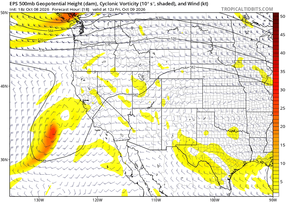
Note the direction of wind barbs in relation to the Sierra late Monday as they shift from primarily SW and SSW, before flipping around to the E and NE. This flow may end up favoring the Eastern Sierra and Sierra front, bringing wrap around moisture up the eastern slopes of the range, enhancing precip. for areas along the Carson Range like Mt. Rose, Freel, and Jobs Peaks.
Lifting dynamics are in place, but what about moisture? Over the past week, this has been one of the main areas of disagreement in the global forecast models, owed mainly to the high degree of variability in Tropical Storm Rachel's track. Should the storm come ashore a hundred miles north or south of a predicted track, there will be large impacts on how much rain and/or high elevation snow any given area will receive. Confidence in precip. amounts remains low to moderate.
Below is a map of ensemble forecast tracks for the center of Rachel. The greatest concentration of forecast tracks (wispy grey lines) are noted by darker red shading. Solid blue and red lines depict the mean forecast track for the GEFS and EPS model ensembles respectively. Dashed red and blue lines are each model's best guess, deterministic track. The solid white line is the "superensemble mean", which combines all global models.

As the storm makes landfall, its moisture will get caught up in the upper level flow around the recently arrived trough. Looking at the moisture plume in PWAT anomaly models (atmospheric water vapor available to precipitate out) helps give a clearer idea of the geographic extent of the tropical moisture, how much is present, and where it's going. As with other variables in this pattern, there is still quite a bit of variation in the models on just where Rachel's moisture goes.
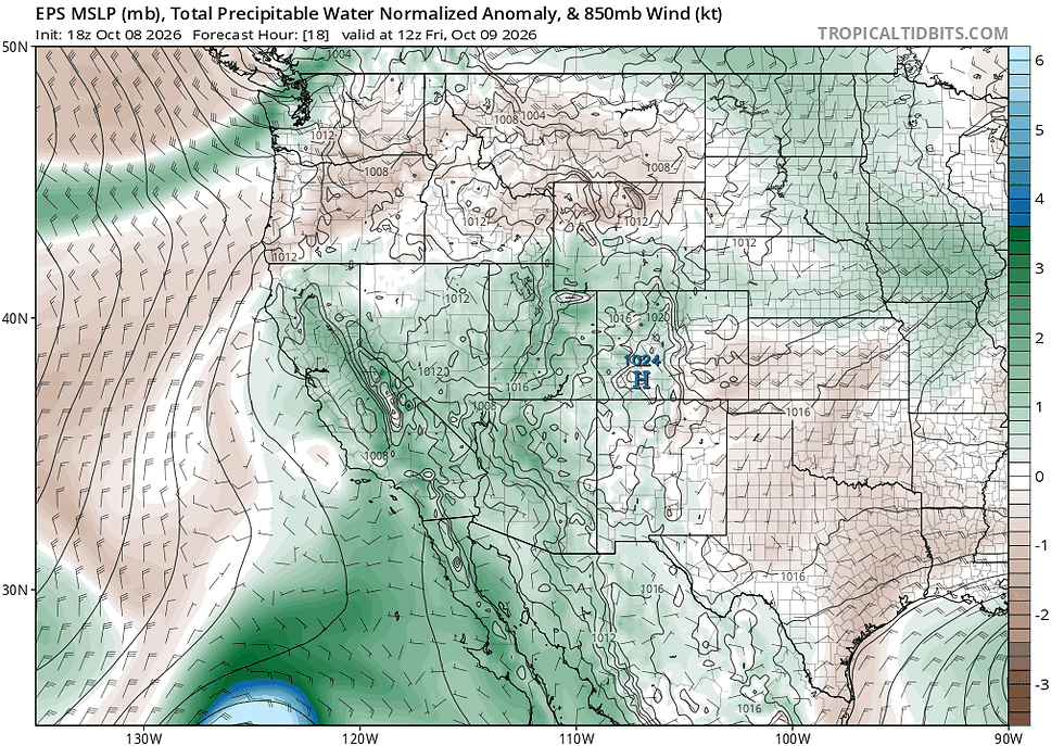
The amount and location of Rachel's moisture with respect to the best lifting dynamics from the recently arrived trough will largely dictate where the heaviest precipitation falls. Total precipitation estimates through Tuesday indicate a wide range of liquid totals with the EPS quite a bit drier than the GEFS ensemble.


How much of this will fall as snow? The limited moisture able to track far enough north into the Tahoe area will likely limit any high elevation snow accumulations for the event. Above 8000-9000', snow showers do look very possible with some modest accumulations (3-5") across the highest peaks, especially on the eastern side and southern sides of the Tahoe Basin with the backside northeasterly flow.

Freezing level guidance does suggest freezing levels flirting with 8000' by late on Sunday afternoon, potentially falling a bit lower (~7500) overnight Sunday into Monday morning. However, as noted in the spaghetti plot below, forecast uncertainty still shows a wide range of outcomes in the Sun PM - Mon PM time frame (00z on Mon, 10/12 - 00z Tues, 10/13).

Beyond Tuesday, models suggest the large scale low shifting out to the east, giving way to dry weather and moderating temps as high pressure returns to the region for mid - late next week.
In a complicated and roundabout way, a tropical storm may indeed bring the first snows of the 2027 water year to the Tahoe backcountry. But with only modest, cosmetic accumulations left in the storm's wake, this weekend's storm will act as a reminder to pull down the ski gear and start getting it ready for colder and wetter storms to come.


Comments