Weekend forecast 10/2-10/4: Second summer with warm, dry - and at times smoky - conditions continuing into the coming week

Updated: Oct 2
A persistent ridge of high pressure has set up over California and the west for the coming weekend bringing above normal temps, light winds and generally cloud-free skies. Some drifting and lingering smoke from area wildfires may produce pockets of smoke and hazy skies through late weekend.
Fri, 10/2/2026: 6:00am - Sat, 10/3/26: 6:00am | |||||||
Temps. (Max/Min) | Wind | Cloud Cover | Precip. Prob. | Precip. Amount | Precip. Type | Notes | |
7000-8500' | Max: 68-73° Min: 55-59° | SW @ 5-10mph | Mostly clear | 0% | n/a | n/a | Mostly clear and warm. Lingering AM smoke will likely disperse to PM haze |
8500-10k' | Max: 64-68° Min: 50-54° | SW @ 10-20mph | Mostly clear | 0% | n/a | n/a | Mostly clear and warm. Lingering AM smoke will likely disperse to PM haze |
Sat, 10/3/2026: 6:00am - Sun, 10/4/26: 6:00am | |||||||
Temps. (Max/Min) | Wind | Cloud Cover | Precip. Prob. | Precip. Amount | Precip. Type | Notes | |
7000-8500' | Max: 70-75° Min: 54-59° | SW @ 5-10mph | Mostly clear to a few PM clouds | 0% | n/a | n/a | Mostly clear and warm. Lingering AM smoke will likely disperse to PM haze |
8500-10k' | Max: 63-69° Min: 50-54° | SW @ 10-20mph | Mostly clear to a few PM clouds | 0% | n/a | n/a | Mostly clear and warm. Lingering AM smoke will likely disperse to PM haze |
Sun, 10/4/2026: 6:00am - Mon, 10/5/26: 6:00am | |||||||
Temps. (Max/Min) | Wind | Cloud Cover | Precip. Prob. | Precip. Amount | Precip. Type | Notes | |
7000-8500' | Max: 69-73° Min: 55-58° | SW @ 5-10mph | Few to scattered | 0% | n/a | n/a | A few more clouds may build in PM. Smoke and haze may linger. |
8500-10k' | Max: 64-59° Min: 51-55° | SW @ 10-20mph | Few to scattered | 0% | n/a | n/a | A few more clouds may build in PM. Smoke and haze may linger. |
Backcountry Conditions:
The continuation of dry weather over the past week has done little to improve trail conditions across the backcountry at all elevations. Parched dust remains the main course on offer for trails around Tahoe. Meadows are brown, crispy, and thirsty for fall rains. Along riparian zones, fall color is peaking below 8000' with aspens, willows and alders showing off the best yellows and golds they can muster in the dry conditions. Upper elevations above 8000' have already started losing foliage and are now past peak, despite the warm temps.
Forecast Analysis:
Second summer is here for the foreseeable future with stable weather, above average temperatures, and mostly light winds through the weekend and well into next week.
Models show a ridge of high pressure anchored over the west showing no signs of moving out for the weekend, and it may rebuild later next week. While the ridge is in residence, any systems approaching from the area will likely be deflected up and over California, preventing any noticeable changes to the dominant pattern other than a few clouds, slightly increased breezes, and temperature drops of just a few degrees.

Later in the weekend forecast period (Sunday PM into Monday), a weak area of low pressure approaches CA from the west, but is largely deflected away from the area.
The approaching weak low is more visible by taking a look at the Euro model depicting lifting dynamics and winds half way up in the atmosphere (500mb vorticity). The spinning area of vorticity encounters the ridge of high pressure and flattens it slightly, but not before having its dynamics spilled out and diluted over CA and the Great Basin.
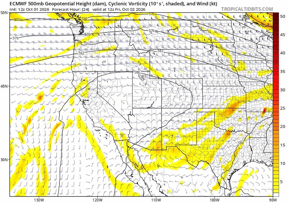
What does this all mean on the ground? Not too much. As the weak low approaches the Sierra by late in the weekend, a few puffy clouds may build across the skies late Sunday. There will be some weak monsoonal flow in the area streaming up from the south and east, providing some fuel for afternoon clouds and maybe a shower as noted in the EPS precipitable water normalized anomaly forecast below.

Combined with the weak dynamics of the approaching low, the modest moisture surge from the SE may provide enough fuel to fire off a shower or thunderstorm in the Great Basin or Eastern Sierra, but chances look quite low: 5-10% as of late Thursday, 10/1.
While rain chances are nada through the period, smoke from the Dome Fire in the Yosemite wilderness and a few prescribed fires across California may drift into the Tahoe Basin and linger through the weekend due to the stable airmass and weak atmospheric transport winds.
HRRR near surface smoke forecasts show the smoke slinking about Tahoe early Friday.

While the Dome Fire in Yosemite is far from a rager, consuming around 100+ acres per day for the past week, Yosemite officials are allowing it to act as a prescribed burn to promote beneficial landscape impacts in the Yosemite backcountry. With no rain in sight, the fire will produce smoke lingering around the region until more robust winds and dispersal conditions help to clean out the air. Expect some smoke and hazy conditions for the near future until the pattern shifts.
Looking ahead into next week, ensembles favor a rebuilding of the ridge which will keep Tahoe warm and dry, likely persisting until the following weekend.

There are some hints in the ensembles that the ridge may weaken or break down next weekend, but confidence this far out is low.
For now, summer's back. Enjoy it while it's here!


Comments