Mixed bag Halloween weekend with rounds of mountain rain/snow Fri.-Sat., followed by clearing Sun.: Weekend Forecast (10/30 - 11/2)

An active pattern will bring cool temps and rounds of rain and snow showers Friday - early Sunday, with good potential for 5-8"+ new snow across the backcountry. Drier and slightly warmer conditions return late Sunday into next week. Unsettled weather with additional rain/snow chances could return by midweek.
Fri, 10/30/2026: 6:00am - Sat, 10/31/26: 6:00am | |||||||
Temps (Max/Min) | Wind | Cloud Cover | Precip Prob | Precip Amt | Precip Type | Notes | |
7000-8500' | Max: 37-42° Min: 32-35° | WSW 10-20mph | Overcast to broken overcast | 90% | .15"-.30" liquid / trace-1" frz | rain/snow | Highest precip amounts west and snow levels climbing during day Fri., falling Fri PM |
8500-10k' | Max: 30-37 ° Min: 29-32 ° | WSW 15-25, gusts to 30mph | Overcast to broken overcast | 100% | .15"-.35" liquid / trace-2" snow | snow | AM snow showers become spotty, then reemerge Fri PM through Sat AM |
Sat, 10/31/2026: 6:00am - Sun, 11/1/26: 6:00am | |||||||
Temps (Max/Min) | Wind | Cloud Cover | Precip Prob | Precip Amt | Precip Type | Notes | |
7000-8500' | Max: 35-40° Min: 27-31° | SW 10-20mph | Sct overcast to overcast | >90% | .25"-.5" liquid / 3-6" snow | mix early / snow | Snow increases through the day Sat into Sat PM. Highest amounts west |
8500-10k' | Max: 26-35° Min: 24-31° | SW 20-30mph | Sct overcast to overcast | 100% | .30-.70" liquid / 4-8" snow | snow | Snow increases through the day Sat into Sat PM. Highest amounts west |
Sun, 11/1/2026: 6:00am - Mon, 11/2/26: 6:00am | |||||||
Temps (Max/Min) | Wind | Cloud Cover | Precip Prob | Precip Amt | Precip Type | Notes | |
7000-8500' | Max: 34-41° Min: 24-28° | SW 10-20 becoming NE 15-25mph | Overcast to few | 90% | .05-.15" liquid / 1-2" snow | snow | Snow showers early Sun, clearing by afternoon. Winds turning NE |
8500-10k' | Max: 28-31° Min: 19-24° | SW 15-25 becoming NE 25-35mph | Overcast to scattered | 90% | .05-.15 liquid / 1-2" snow | snow | Snow showers early Sun, clearing by afternoon. Winds turning NE |
Backcountry conditions:
This week the backcountry hosted a mix of transitional conditions typical for late fall including everything from a shallow, crusty snowpack to cold, firm dirt, to icy cold mud. In general, the Sierra Crest missed out on much of last week's snowfall while high elevation zones along the Carson Range generally picked up more snow that persists across colder aspects.
Across the Carson Range, snow from last week's storm system remains above 8000' on shady, NW-N-NE aspects and in forests. Recent cool, dry conditions and the low October sun angle have tipped the balance away from a quick meltout and towards the slow backcountry transition to winter. Trails are icy in many spots, especially above 9000' and the modest snow depth is enough to make biking difficult at upper elevations, but not yet skiable.
Less snow fell along the Sierra Crest last week, resulting in trail conditions better resembling fall than winter, even at higher elevations. While snow patches remained on NW-N-NE aspects and in the highest protected zones from Desolation to Donner Summit, it was far patchier and shallower than in the Carson Range. The current round of unsettled weather this weekend will, however, change this, bringing more snow to the Crest, leveling out the current snow disparity between eastern and western zones.
Forecast Breakdown:
Cooler temps and unsettled weather will bring periods of light-moderate snow showers in two rounds: the first Friday morning-early afternoon, and the second cooler and more robust round Saturday through the first half of Sunday. Sunny, dry, and modestly warmer conditions return to Tahoe early next week. Current model guidance suggests areas along the Sierra Crest and south of Tahoe receiving the most precipitation, with a 40-60% chance of 8" or more above 8000' by early Sunday, while similar probabilities of up to 6"+ exist in the Carson Range. Temperatures all weekend will be chilly with highs generally in the upper 30s to upper 20s across the mountains from 7000-10,000' accompanied by brisk SW-W flow.
The culprit for this weekend’s storminess is a split pattern between a deep, cold low hanging off the PNW, merging with a subtropical low over the Pacific southwest of California. Models this week have struggled to find a consistent solution with this pattern and further tweaks are very possible over the weekend. Model solutions significantly increased precip. amounts and probabilities over the past 24 hours after trending drier for most of this week. Needless to say, forecaster confidence is moderate at best.

Friday through early Sunday Tahoe will be under the influence of a closed upper low centered around the mouth of the Columbia River. The combination of dynamic lift from the low to the north and subtropical moisture getting drawn in from the SW combines to produce two rounds of mountain rain/snow: the first lighter with a shortwave on Friday, then a more robust round Saturday through early Sunday as the energy from parent low over the PNW elongates and kicks out of the region.

Worth noting is how the upper flow noted in the wind barbs may turn more southerly late Saturday. This flow typically favors less moisture spillover east of the Sierra Crest, translating into less precip. for the Carson Range and more along the west side of the Tahoe Basin.
Sufficient moisture already in place on Friday will increase into Saturday, allowing for the low to efficiently wring out snowfall over the mountains late Saturday into Sunday. Most recent model guidance points towards areas from Tahoe south into the Central Sierra as having the most moisture available for the second wave of energy.

The heaviest and most widespread coverage of rain/snow will occur where the best dynamic forcing combines with the highest amounts of moisture. Snow totals will vary greatly should the moisture-supplying system to the south move through a bit further north or south.
Current ensemble guidance favors the Sierra Crest from Tahoe south as potentially receiving up to 1"+ of liquid. Across the Tahoe Basin, this likely translates to ~1" of liquid for areas along the crest to ~.5"-.75" along the Carson Range.
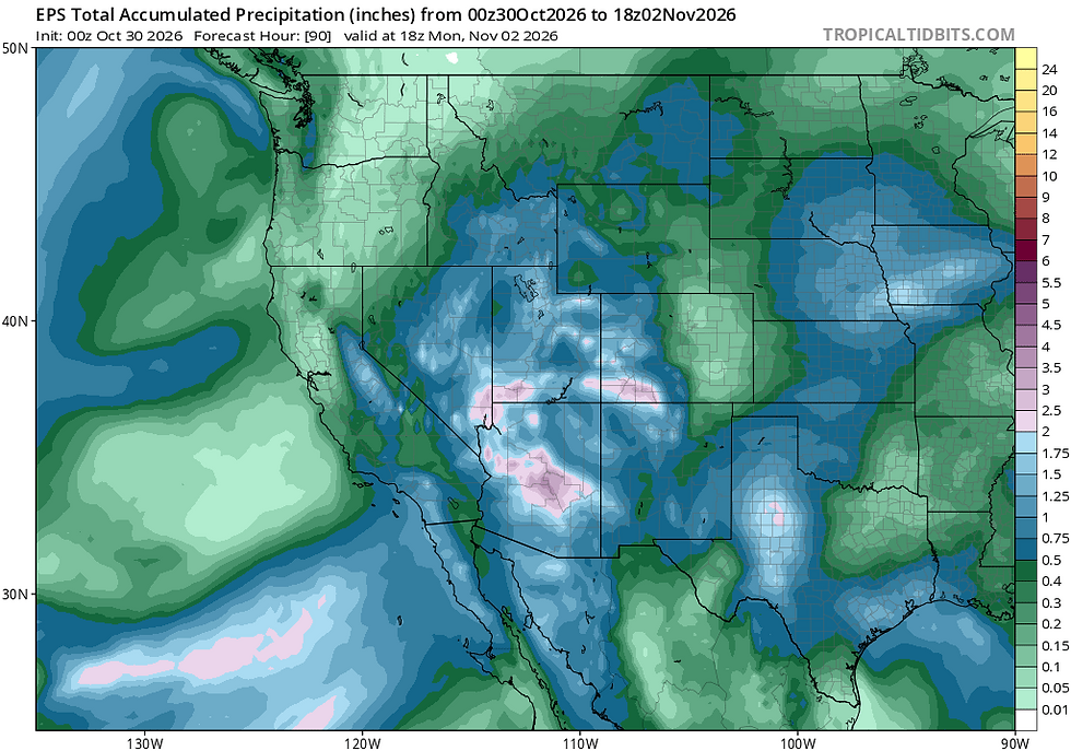
Temperatures this weekend will be cool under the influence of the low in the PNW. Snow levels look to start around 7500' on Friday, rise through Friday afternoon to around 8000'-8500', then fall again overnight into Saturday, before rolling downhill towards lake level early Sunday morning as showers diminish.

Given the temperatures and the above layout of the pattern, higher backcountry zones along the Sierra Crest have a good chance of receiving 6-8"+ of new snow by Sunday morning, with upper elevations in the Carson Range generally between 4-6"+. Lower totals can be expected across lower elevations, but a few inches of coverage looks likely across all backcountry areas above 7000' by Sunday morning.

By Sunday, unsettled conditions will move out of the region as a ridge of high pressure builds in bringing sunny skies and moderating temperatures. It will still be cool with some northeasterly breezes initially, but temperatures going into the beginning of next week will climb modestly to near normal.
This weekend's round of rain/snow looks fairly modest by Sierra standards, but it will likely put the backcountry into solidly shoulder season status with a thin snowpack forming the base for the season to come.
Long term:
A ridge of high pressure ushering in warmer temperatures, light winds and sunny skies will build in for the early part of next week. Later in the week and into the following weekend, guidance signals a return to a stormier pattern, but details remain nebulous. Further out into November, there are signs of a more "classic" north Pacific pattern with storms riding an active jet stream across the ocean and into the west coast.
Snow season isn't here yet, but signs are beginning to point towards its imminent arrival.


Comments