Rains return, trails improve, and the specter of significant snowfall lurks in the long range: Weekend Forecast (10/23 - 10/26)

Updated: 3 days ago
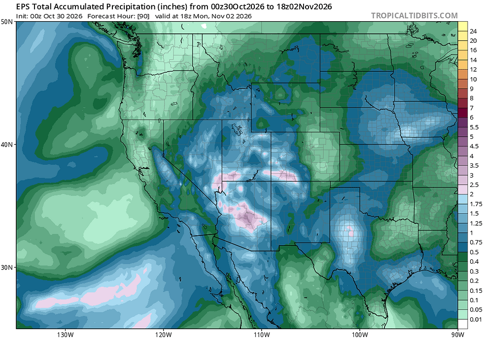
Crisp mornings and cool, sunny days are in store this weekend as high pressure and dry conditions build back into the Sierra, likely lasting well into next week. Late next week into the beginning of November, models suggest the arrival of a colder and wetter pattern with the potential for the Sierra's first significant snows of the season.
Fri, 10/23/2026: 6:00am - Sat, 10/24/26: 6:00am | |||||||
Temps (Max/Min) | Wind | Cloud Cover | Precip Prob | Precip Amt | Precip Type | Notes | |
7000-8500' | Max: 41-47° Min: 28-32° | NW - NE @ 10-20mph, gusting to 30 | Overcast to scattered | 20-40% | trace | snow then mix | Clouds clearing Fri. Cold Sat AM, especially in protected areas |
8500-10k' | Max: 32-41 ° Min: 22-26° | NW - NE @ 20-30mph, gusting to 40+ | Overcast to scattered | 40-60% | trace | snow | Strongest winds along the Sierra Crest. Lingering clouds along E. peaks |
Sat, 10/24/2026: 6:00am - Sun, 10/25/26: 6:00am | |||||||
Temps (Max/Min) | Wind | Cloud Cover | Precip Prob | PrecipAmt | Precip Type | Notes | |
7000-8500' | Max: 44-52° Min: 28-35° | E @ 5-10mph | Few to mostly clear | 0% | n/a | n/a | E breezes becoming light and variable into Sun AM |
8500-10k' | Max: 36-44° Min: 23-28° | E @ 20-30mph decreasing | Few to mostly clear | 0% | n/a | n/a | Winds begin brisk from E then slacken throughout the day becoming variable |
Sun, 10/25/2026: 6:00am - Mon, 10/26/26: 6:00am | |||||||
Temps (Max/Min) | Wind | Cloud Cover | Precip Prob | Precip Amt | Precip Type | Notes | |
7000-8500' | Max: 51-58° Min: 32-38° | SW @ 10-15mph | Few to scattered | 0% | n/a | n/a | SW winds light Sun increasing into Mon |
8500-10k' | Max: 43-51° Min: 28-32° | SW @ 25-35mph, gusts to 40+ | Few to scattered | 0% | n/a | n/a | SW winds starting light Sun increasing into Mon |
Backcountry conditions:
This week’s rain and high elevation snows from 10/21 - 10/23 transformed backcountry trails from blown out, dusty, Grapes of Wrath- like conditions to tacky, and fragrant fall glory. The dust is gone, replaced by "brown pow", the perfect springy, moist trail surface that mountain bikers eagerly await with the return of fall rains. It's finally here.
Accumulating snowfall reached down all the way just below 8000' feet as of this morning (10/23), and will quickly melt over the course of the weekend with the return of sunny skies and highs in the 40s and 50s. Do expect some snowy patches to remain above 8500’ on shady NW-N-NE aspects where the deepest snow fell. Trails will remain passable through the light snowfall and improve over the weekend.
Expect morning inversions to be moderate/strong especially Saturday and Sunday mornings with drainages and depressions 10+ degrees colder than adjacent ridges and summits. Low lying areas may also develop patchy freezing fog.
Storm Recap (10/21-10/23):
After nearly eight weeks of waiting (last rainfall of .31" on 8/29), this week’s storm brought much needed rainfall to the Tahoe backcountry and the season's second snowfall to higher elevations above 8000'. Most noteworthy is the strong thunderstorm activity the afternoon of 10/21, which dropped .90” of water above Incline Village, peaking at a rate of .97” per hour during the evening of the 21st! Frequent lightning and small hail accompanied the event.
The low responsible for the excitement had all the markings of influence from El Niño's teleconnections and the east Pacific marine heat wave. The storm dropped in from the north a few hundred miles west of the CA coast, but meandered, spinning over the Pacific off Central CA for a few days before coming ashore near Point Conception on Thursday (10/22).


The extended residence time of the storm over warm waters allowed the system to draw in warm moist air from the Pacific, modifying its original, cool, N. Pacific air mass with the added warmth of air getting pulled in from the subtropics. This allowed the low to hold more moisture than a colder system, but initially, also kept snow levels across the Sierra very high (10,000'+), until cooler air, pulled in from the north, arrived on the backside of the system, bringing snow levels down to below 8000'.
Take a look at sea surface temperature (SSTs) anomalies off the CA coast in the area where the low sat and spun last week. SSTs were between 3-5°C degrees warmer than average, which translates to 5.4°-9°F! That's quite a bit of extra heat available to transfer from the ocean to the atmosphere.

High snow levels and greater amounts of convective energy (heat-powered rising air) are the types of impacts to be expected when storms sit and linger over warm waters off the CA coast. As fall turns to winter, it's worth watching how future storms arrive into the Sierra and whether they track in on a robust jet from colder latitudes, or come in and marinate in the warmer waters off the coast, soaking up heat and drawing in tendrils of warm, subtropical flow. The flavor and track of each storm will have consequential impacts on snow potential and character for the Tahoe backcountry this season.
Forecast Breakdown:
Cool and generally tranquil fall weather will follow up this week's storm with clearing skies and generally dry conditions over the coming weekend. Scattered clouds and showers may linger on the mountains on Friday morning, followed by sunny and crisp conditions for the remainder of the weekend. Temperatures will moderate a few degrees each day with Sunday being the warmest day of the period.
Big picture-wise, model ensembles show good agreement in this week's system trekking slowly southeast into the Four Corners, weakening along its journey. In its wake, a weak, shortwave ridge forms over northern California, which will help to clear skies and moderate afternoon highs to near normal later in the weekend.

Much like last weekend--and as is typical this time of year--the interplay of the departing low to the east and the ridge to the northwest will create an east-west gradient, initially supporting northeast and easterly winds and upslope flow along the Carson Range on Friday - Saturday, before turning back around to the southwest Sunday as a new system approaches the Pacific NW.

Over the first half of the period, NE - E flow will keep temperatures seasonably cool across the higher elevations with brisk breezes throughout the weekend. Don't be surprised if some low clouds and maybe even a few flurries develop along the east side of the Tahoe Basin on Saturday morning. Expect summits and ridgetops to be chilly as well, especially through Saturday. Pack a puffy!
Extended Outlook:
As the weekend closes, a cutoff low in the Pacific NW will begin to make an entrance onto the west coast on Monday, ushering in a return of southwesterly flow for the Sierra. Current guidance keeps most of the action to the north of Tahoe next week as the aforementioned low pushes eastward into ID and MT.
Towards the end of the week and into early Nov., signs have emerged--and have been fairly consistent across the models this week--for a troughy pattern over the eastern Pacific. This is a setup that could favor more significant cold and snowfall in the Sierra from next weekend into the beginning of November.
Confidence this far out is low, but it's worth keeping an eye on.

Even NOAA's Climate Prediction Center has hinted at the possibility of heavy snow in its extended outlook.

Whatever happens, this is another good reminder that the transition to winter is not far away.


Comments